


You are free to reproduce any of the text of this work for non-

This work is licensed under a Creative Commons Attribution-NonCommercial 2.0 UK: England & Wales License

a
Gazetteer
© RRRA, 2026
updated 20 July 2026
pages created by Mike Haken, updated 10 July 2026
Digital Britannia
This project began after I found myself increasingly bemused by the many different maps of the Roman road network I was seeing in publications and at conferences, none of them ever being a particularly good representation of the current state of knowledge, and often based on the work of Ivan Margary – who died fifty years ago. Far too many, especially in England, included or excluded roads that had never been thoroughly assessed and some supposedly authoritative scholarly publications are still including the work of the group known as The Viatores from the 1950s and 1960s, whose work is now largely (but not entirely) discredited.
The only readily available digital mapping of Roman roads in Britain were the excellent digitisations by Mike Bishop of the work of Codrington (1903), the Viatores (1964), Margary (1967), and a few others of similar vintage -
The only solution was to create a new map by re-
A) A typical surveyed and engineered Roman road
B) Roads in use during the Roman period, but without typical Roman engineering or surveying. Well known examples include Caistor High Street in Lincolnshire and parts of the Icknield Way in Norfolk.
C) Roads previously claimed as Roman, for which there is no evidence of Roman origin or use in the Roman period.
For clarity, and to avoid creating any misleading impressions, these groups were recorded in three distinct layers.
.
A new digital map of Roman Britain, by Mike Haken
- Identify known and supposed roads from primary sources and other existing scholarship
- For each road, assess whether or not the evidence is sufficient to confirm its existence. For roads that clearly do exist, the following three stages are then followed.
- Analyse the previously recorded routes for each road and the evidence for each road segment, and plot each segment digitally using QGIS.
- Compare the supposed routes of each segment with topographic data to assess gradient (Roman roads hardly ever exceed 1 in 6 gradients), along with lidar imagery and aerial photography, and adjust the course of the segment if necessary.
- Award each segment a confidence rating where ‘3’ is a known road accurate to within 20m, ‘2’ a known road accurate to within 200m, and ‘1’ is a conjectured route of a known road. .
Basic methodology for assessing Roman roads
Background
The intention here is to produce as accurate a picture as possible of the current state of understanding regarding the Roman road network in Britain, which has necessitated making valued judgements about what to include, and what not to. This was not always straightforward, since local Historic Environment Records differ in how they record Roman roads, with a few treating all roads that have ever been claimed to have Roman origin in the same way as those whose Roman origin is not in doubt, whereas others tend in the opposite direction, with a reluctance to accept very obvious aerial photographic and lidar evidence without corroborating excavation. Consequently, what is represented in Digital Britannia may sometimes differ substantially from the local HER.
It is important to stress that whilst this work is being released through the RRRA, all editorial decisions have been my own, as are any of the inevitable errors. Certainly, there are instances where I do not quite agree with other researchers, but where that is the case, I have tried to make my reasoning clear in the accompanying text.
The initial release contains the following
The new map
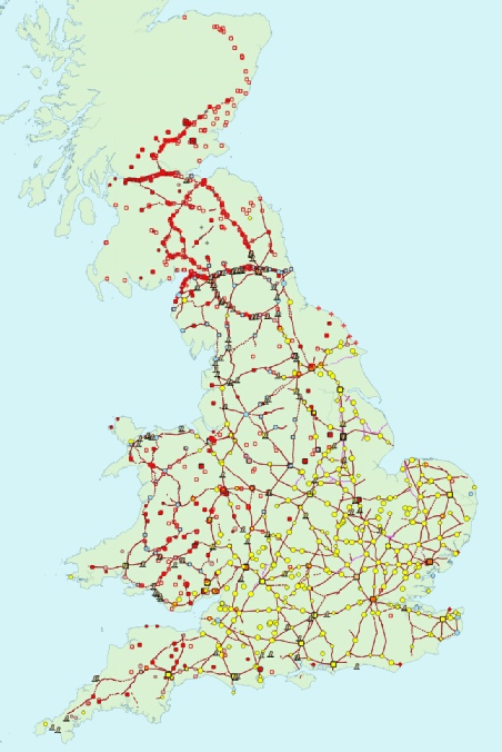
- 482 nucleated or agglomerated settlements, including military vici.
- 517 military installations, including signal towers
- Both Roman walls, along with the Vallum.
- 78 milecastles & 166 turrets on Hadrian’s Wall (utilising WallCap data).
- 617 temporary camps
- 132 Roman milestones
- 3,577 engineered road segments mapped, nearly 8,000 miles of Roman road
5,567 features -
Two further layers are currently under construction, covering categories B & C above.
- Other significant roads (not including trackways having purely local function) that can be shown to have been in use during the Roman period, but which do not show any signs of classic Roman road surveying, ie no straight lengths. -
Release expected August 2026 - Previously claimed roads which are now either rejected, disregarded, or have some potential but insufficient to be included in the main Engineered Roman roads layer. There are alot of these, including many that were recorded by Margary, in my view erroneously. Release expected late 2026.